All dowsing is done remotely from a map of your property.
In order to dowse your property for underground water location possibilities, I will need a property address or AP#
I can refer you to a specific driller for Sonoma, Napa, Marin, Mendocino counties if you wish.
Water dowsing can be done anywhere in the world, as long as we can see it on Google map.
Please send any requests/questions to the email address below, adding Dowsing in subject line.
Thank you
Eli.lamond@gmail.com

What to expect from this process:
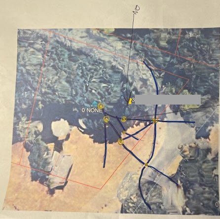
An overall preliminary map of the property with “some” of the water veins and best places to drill to get the most amount of water.
A close up map of where you have decided the best place to drill with your driller, considering all the various setbacks necessary, septic, property lines, etc…
At this point, I will re-dowse an exact location and give you an “APPROXIMATE” depth and volume that you can expect.
This system will only work IF the driller of your choice is drilling as close as possible to the dowsed location. Any deviation could negate everything and result in a dry hole or different results.
Predicting numbers can be extremely difficult with distance dowsing on a map, but usually, I can give you an overall idea.
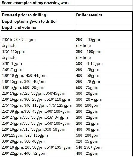
See examples below.
Please read the testimonial below
Example above: in feet and gpm (Gallon Per Minute to the surface)
Dowsed location from address and map prior to drilling.
Giving various options to the driller, to leave to his best judgment regarding the terrain stability and various expectations:
300’ depth, 20gpm, 500’ depth, 40gpm
Results drilled at location: Drilled to 320’ depth, 35gpm water
Example above: in feet and gpm (Gallon Per Minute to the surface)
Dowsed location from address and map prior to drilling.
Giving various options to the driller, to leave to his best judgment regarding the terrain stability and various expectations:
200’ depth, 10gpm, 285’ depth, 30gpm, 540’ depth, more than 135gpm
Results drilled at location: Drilled to 540’ more than 150gpm

.
Example above: in feet and gpm (Gallon Per Minute to the surface)
Dowsed location from address and map.
Giving various options to the driller, to leave to his best judgment regarding the terrain stability and various expectations:
280’ depth, 22gpm, 430 to 440’ depth, 52gpm,
Results drilled: Could not drilled location dowsed due to access: Drilled to 400’, 25gpm - Water was found at 220’, 10gpm and 300’, 25gpm

Being a Property Ranch Manager, I started dowsing out of necessity, trying to locate broken pipes for leaks or underground septic tanks.
I also do dowsing for health purposes, searched for a missing plane over the Sierras, missing animals, gold veins etc..
Although this is not an exact process and comes with no guarantee,
Close to a hundred of well dowsing sessions, this past year, I am more often correct than wrong. ;)
I also highly recommend consulting a hydrologist or engineer to ensure accuracy,
as drilling a well is an expensive undertaking. Map dowsing cost is minimal.
For this service, send an email, adding Dowsing in subject line.
Thank you
Elizabeth
Email: Eli.lamond@gmail.com
____________________________________________________________________________________________________________________________________
Testimonial:
My name is Steve Unterseher, Vice President of Fisch Bros Drilling. I’ve been in the industry for over 37 years, and Fisch Bros has been in business since the early 1970s.
I met Elizabeth about a year and a half ago on a project we were subcontracted for in Calistoga, CA, where she was the project manager. She told me she had chosen the drilling location herself and had to wait nearly a year to receive feedback on her dowsed location. We drilled at the marked dowsed location and we were able to develop a great well with plenty of water.
Elizabeth was very enthusiastic about finding water — and that marked the beginning of our professional relationship. She is one of the most professional individuals I’ve worked with. She was actively involved throughout the drilling process, always curious and asking insightful questions.
Since then, after hearing how long she had to wait for feedback on that first project, I’ve been helping her develop what started as a personal interest into a more serious practice.
I’ve been sending her addresses for upcoming projects and following up with information on whether we found water, how deep we drilled, and the final gallons per minute (GPM) yield. She has been using Google Earth to print maps of these properties and then providing us estimates for the expected best location, depth and water volume.
Now, she no longer has to wait a year for feedback — and she’s been consistently practicing, learning, and growing her business ever since.
In Sonoma County and surrounding areas, there are many different geological formations. Some are more favorable for finding water than others. Drilling in the right geologic material significantly increases the chances of developing a successful well.
When we perform a site visit for a new customer, we rely heavily on the local geology and our past drilling experiences in the area.
Some of our clients hire other specialists to select drilling locations in advance.
Over the years, I’ve seen various methods used — including Hydro Geologists, Water Dowsers, Geophysical Survey companies, and Sonar Imaging Services.
Best regards,
Steve Unterseher Fisch bros. drilling